Mount Hope / Canterbury
This page contains information about the Neighborhood Slow Streets plan for the Mount Hope / Canterbury neighborhood.
Neighborhood Slow Streets is a new approach to traffic calming requests in Boston. We're focused on street designs that self-enforce slower speeds and safer behaviors. Through this program, we aim to:
- reduce the number and severity of crashes on residential streets
- lessen the impacts of traffic, and
- add to the quality of life in our neighborhoods.
Mount Hope / Canterbury is one of five communities that was selected to join the program in 2017.
Canterbury Street Intersection
We will reshape this irregular intersection to reduce visibility challenges, slow turns, and improve the safety of crossings.
Project History
HistoryIn the summer and fall of 2019, we worked to update our designs to reflect community concerns and engineering considerations and bring the plans to the Public Improvement Commission for final approval.
We made final adjustments, including revising the curb extension design at Mt. Calvary Road and Canterbury Street to better address drainage and accessibility to prepare for construction along with other Neighborhood Slow Streets zones in 2020.
We met with residents from 6:30 - 8 p.m. at the Home for Little Wanderers on American Legion. We are accepting feedback on the design through May 16.
After the July 19, 2018, public meeting, we collected feedback on the concept plan through an online survey. Community members were asked to give feedback on:
- a circle or square / four-way stop option for the intersection of Canterbury at Mount Hope Street and Mount Calvary Road
- speed humps and a contraflow bike lane or a chicane (parking switching sides to create an "S" curve) on Mount Hope Street, and
- the concept plan in general.
We met with residents from 6 - 8 p.m. at the Home for Little Wanderers on American Legion.
We joined community members for a neighborhood walk on Wednesday, October 4, at 4:30 p.m. We started at Walk Hill Street and Paine Street. What we learned from the walk will supplement information:
- received in the application
- reported through the Vision Zero Safety Concerns map, and
- collected through speed and volume studies.
Neighbors were welcome to join all or some of the walk. The walk was not the only time or place that neighbors can provide input on the Neighborhood Slow Streets project. Neighbors can also share their concerns at future public meetings about the project.
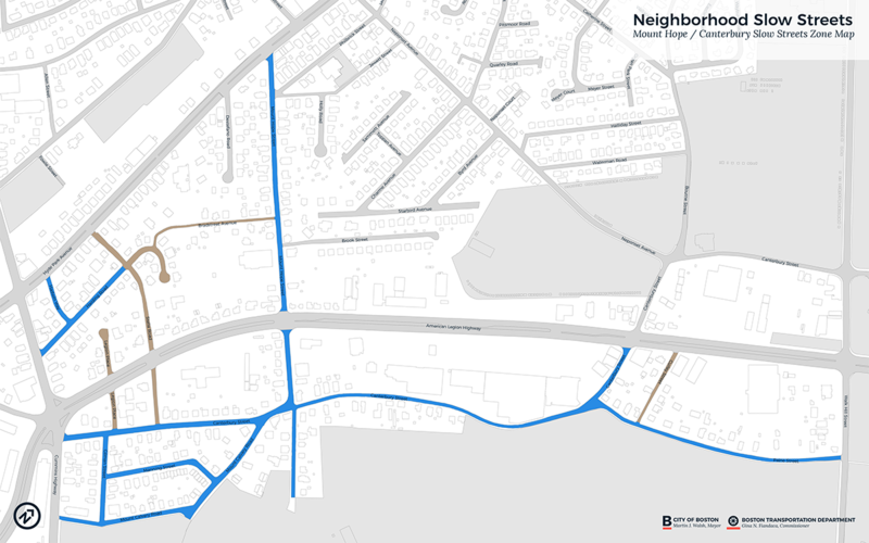
Map of priority area
*All streets that we will consider for changes are marked in blue.
2017 Application Period
Neighborhood Slow Streets prioritizes street safety improvements in areas:
- with a history of serious crashes
- with a high number of residents more likely to be killed or seriously injured walking or biking (children, older adults, and people living with disabilities)
- that include places people may walk or bike to (schools, libraries, parks, community centers, bus stops, or transit stations), and
- near existing or planned opportunities for walking, biking, or taking transit.


